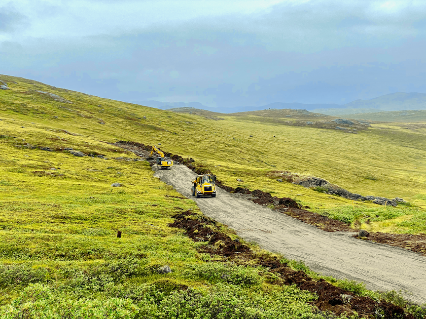
The construction of the Arctic Circle Road, connecting Kangerlussuaq and Sisimiut, commenced in 2020. © Dwayne Menezes
Justin Barnes: What does this road mean for your municipality and its people?
Malik Berthelsen: The road between Kangerlussuaq and Sisimiut will connect the main airport of Greenland and the second largest town of Greenland. It will improve the livelihood of people and give business sectors better opportunities, since the road will connect the two towns with cheap, flexible and independent transportation opportunities and, at the same time, open up the land between the two towns.
I totally agree with renowned professor Minik Rosing’s words about the road: “The road to freedom. Freedom is to be able to travel, exchange ideas and trade with the outside world without barriers. A road between Sisimiut and Kangerlussuaq is the fastest shortcut between the cities on the west coast and the great world. Kangerlussuaq can connect Greenland directly to Asia, North America and Europe. A safe and fast road link opens up opportunities for the export of fresh seafood, allows tourists to quickly stop over in Greenland and offers Greenlanders direct connections to the rest of the world.”
Justin Barnes: What are some of the needs of the communities and how will this road help?
Malik Berthelsen: I think that we, in the Municipality of Qeqqata and in Greenland, need to improve our transport and travel infrastructure and give better opportunities for citizens and businesses to improve their lives and businesses. Just like all other regions and countries do around the world. For Kangerlussuaq, situated on land near the Ice Cap, the road will give year-round access to goods and supplies, since Kangerlussuaq cannot be accessed by ships in the winter months from middle of December to end of May, because the long fiord of Kangerlussuaq is frozen in these months. For Sisimiut, which is situated at the coast, the road will give much better access to the high regularity airport in Kangerlussuaq, thereby lowering the cost, time and uncertainty of getting citizens/businesses, tourists and goods to or from Sisimiut.
Justin Barnes: What have been the primary steps towards building this road?
Malik Berthelsen: The road has been a vision running for many years with ideas and proposals from many interests. The primary steps towards getting the construction started came in 2016 and 2019 when the municipal council allocated DKK 54 million for the construction of ATV tracks and a road to Aasivissuit. The final step, of course, has been that the Government (Naalakkersuisut) has approved the EIA report.
Justin Barnes: How long have you been working towards this goal?
Malik Berthelsen: Since the 1960s, when there was an American airbase with soldiers in Kangerlussuaq, the US Air Force had a proposal to build the road, which unfortunately was refused by the Danish government. Later, it has been a topic of conversation between the municipality and the Government of Greenland, but national politicians unfortunately did not support it for a long period. So, for many years, the municipality has tried to develop the road project on its own. I took over from the former mayor after I became Mayor in 2017. The municipal council had, in 2016, approved DKK 27 million for the construction of a simple ATV track between Kangerlussuaq and Sisimiut. After UNESCO approved our World Heritage proposals in 2018, I suggested that the municipal council build a real road from Kangerlussuaq to Aasivissuit, so we approved another DKK 27 million for this task.
To realise these goals, the municipal council, together with the municipality’s tourism agencies and companies, returned to Nuuk several times to announce the possibilities of the road and published the plan through the press. Last year, the plan started to see support in Parliament (Inatsisartut) and Government (Naalakkersuisut), and I am very happy about the good cooperation that has developed for realising the Arctic Circle Road together. It has also taken many years to get the Environmental Impact Assessment approved, so it is in 2020 that we can start the construction of both the ATV track and the Aasivissuit road.
Despite the good cooperation with the Government, I would like to point out that the start of the road has not received funding from the Government for the start-up, so this summer will see the building of ATV track commence with municipal funds. At the end of 2019, the national government and Parliament on the one hand, and the municipality on the other hand, both approved DKK 5 million each for planning how best to improve upon the ATV track so it can serve as a real road. I hope that Naalakkersuisut/Inatsisartut will co-finance the construction as well.
© Dwayne Menezes
Justin Barnes: Who have been your major partners?
Malik Berthelsen: Fortunately, we have a strong relationship with the municipal council, and in order to realise the road, we work closely with the local business council, Arctic Circle Business, and private companies in the region. Fortunately, the national tourist board Visit Greenland believes that the road will have potential for adventure tourism. In addition, more and more people, companies and Parliament members all over Greenland support the plans. I think we have received this support for our persistence and of course because people can see the potential.
Justin Barnes: What have been some of the major hurdles in getting the road approved and how did you overcome them?
Malik Berthelsen: After the decision by the municipal council to go ahead with the ATV track ourselves without waiting for the Government, the major hurdle has been the approval of the EIA report which has taken a long time. It is something new for our nation that we have planned, and we will now start building the first road between two towns in Greenland, so it is also new for the Environmental Department in the Government to approve such a plan.
Justin Barnes: What kind of environmental concerns emerged and how did the council find a balance?
Malik Berthelsen: There are several areas that we must be careful and safeguard – for example, special lakes, geese, reindeer and musk ox. Wherever possible, the destruction of the landscape should be avoided. Concerning the animals, there are too many reindeers in the region, and the Nature Institute fears a collapse, because more than 100,000 reindeers might not find enough food. It is the opposite with the geese where the Greenlandic geese are endangered and red listed, partly because they can compete with Canadian Geese coming to Greenland. Therefore, we have focused on moving the road away from the areas where the few Greenlandic geese are, but not to the same extent with respect to the reindeers, because they are everywhere. In terms of balance, I think there should be room for all of us. For example, with regard to reindeer hunters, there is one area in the stretch which is a reindeer hunting area, and some reindeer hunters are opposed to the stretch of road located in that area. Of course, I understand their concern, but with regards to the geology, unfortunately, we cannot take the road in the other direction.
Justin Barnes: What kind of boost will this road give to the local and Greenlandic economy?
Malik Berthelsen: The road will give better access to Kangerlussuaq and Sisimiut, and improve the conditions for almost all the businesses in both places. I focus very much on how to develop our economy by making improvements for the existing export/foreign income earning sectors in Kangerlussuaq and Sisimiut. In Kangerlussuaq, this is mainly tourism and the research sector. In Sisimiut, this is mainly fisheries and tourism.
The research sector will get better and cheaper opportunities to explore climate change and research topics, from the Ice Cap at Kangerlussuaq to the coast of Davis Strait at Sisimiut. The fishing industry will get better opportunities to export freshly caught products, like our neighboring countries, instead of only exporting frozen seafood. However, the tourist potential of the road is probably the biggest game changer for the Greenlandic economy. The road will give tourists new all year-round possibilities to stand on the Ice Cap near Kangerlussuaq, explore the Arctic countryside and see the Davis Strait near Sisimiut in buses, cars and ATV/UTVs at low costs.
The existing year-round tourism in Kangerlussuaq can spread, first to Sisimiut, and then further on to the neighboring seaside towns of Aasiaat and Ilulissat, north of Sisimiut, and Maniitsoq and Nuuk, south of Sisimiut. With new airports in Ilulissat and Nuuk, there will be the opportunity to develop round tours that incorporate both Kangerlussuaq and Sisimiut via road and then Ilulissat or Nuuk from where tourists can depart from the new airports, thus lowering the cost substantively and giving tourists the opportunity to experience the land. I believe this will give the tourism sector in Western Greenland a massive boom all year round, instead of only having tourists in the summer season. Together with the new airports in Ilulissat and Nuuk, the road make this possible.
It is important to diversify our economy, which is very dependent on fisheries. We have already seen in our municipality and the country how fragile it is with fishing as a primary source of income. For example, for the last two years, our fishermen have had several million DKK less in income because the cod disappeared. The result was fewer workers in fish factories and lower tax income. Tourism is the most obvious way to create new jobs for our Greenlandic economy. Minerals are the second-best opportunity. Public infrastructure investments are needed to change this situation and open up the tourism potential.
Justin Barnes: How does this road fit into your plans for developing the tourism industry?
Malik Berthelsen: The road is by far the best and most needed public infrastructure investment in our region and fundamentally important for our tourism development. Other regions see potential in building new airports and enlarging their airports in the towns on the coast, thereby attracting tourists. However, in the Municipality of Qeqqata, we know the limitations of our airports on the coast. We have 799-meter-long runways in Sisimiut and Maniitsoq, but the challenges of the mountainous terrain and the weather systems on the coast will make it extremely expensive to enlarge these airports and impossible to get their regularity near the regularity of Kangerlussuaq airport, which is 99.8%.
In Greenland, there are no roads between two towns/settlements. Kangerlussuaq has the largest road network in Greenland which spans from the Ice Cap via Kangerlussuaq to the harbour of Kangerlussuaq. This 50 km long road gives tourists access to watch the glacier front of the Ice Cap for 15 km, as well as the opportunity to stand on the Ice Cap itself. It was built by the car company Volkswagen when they had a car testing facility on the Ice Cap from 1999-2004. Now, more than 15,000 tourists go by buses and cars to the Ice Cap along this road. It is by far the most visited tourist attraction in the Municipality of Qeqqata, maybe the largest in Greenland.
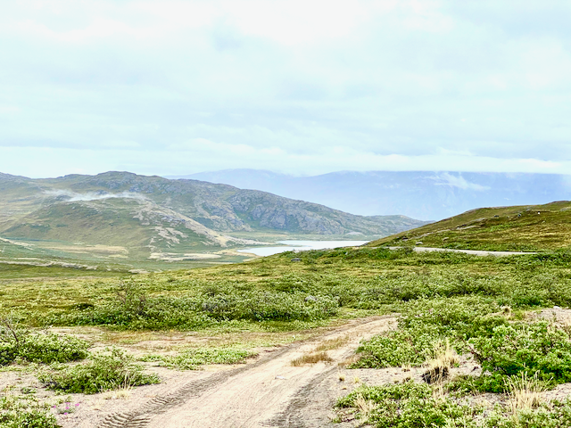
The Municipality of Qeqqata has the largest and broadest land area between the Ice Cap and Davis Strait in Greenland, as well as the largest town on land in Greenland, so it is obvious for us to explore more road opportunities. While the coast frequently experiences tough weather, the land behind the coast has better weather and offers tourists many potential options. Roads have developed almost all countries and tourist destinations, where tourists go by tour buses or rent cars to get around. The municipal council went to Iceland a year and a half ago and experienced how important the roads are for tourism in Iceland. Tour buses drive around the Golden Circle near Reykjavik, and tourists rent cars to drive around Iceland. We have tourist attractions of at least the same scale as Iceland in the land area between the Ice Cap and the Davis Strait. The road will create better access to these attractions.
Furthermore, if we do not develop our region, it will fall behind in tourism and businesses related to the construction of airports in Nuuk, Ilulissat and Qaqortoq. We must also be able to present exciting offers to the outside the world, and the road is our best offer. When the road is ready, there will be different options for adventure tourism. It’s these that make the most value in earning. We are lucky, since we have such a large area of land that is available all year, and in this, we will increase profit.
Justin Barnes: What will this road help to access?
Malik Berthelsen: The area between Kangerlussuaq and Sisimiut offers many opportunities to tourists. The Arctic Circle Trail is known as the most adventurous hike in the Arctic, is hiked by more than a thousand hikers each summer, and is used by sledge, snowmobile, fat bikes and cross-country skis in the winter. However, hikers don’t spend much money locally, since they often bring their own food and sleep in their own tents or use the free municipal huts along the trail.
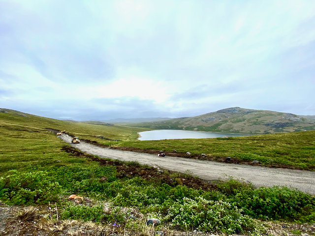
What we need is accommodation along the road, hotels and lodges where tourists and locals can spend the night and enjoy the magnificent area. As for that, there is increased interest in the “pristine” Arctic and landscape. In addition, on the stretch between Sisimiut and Kangerlussuaq, municipal allowances have been added to build a luxury hotel. The area is midway between Kangerlussuaq and Sisimiut, which has fantastic views of the lake and mountains. An improved infrastructure with the road and hotels will give tourists more security and attract new types of tourists to the area, including families and older people in addition to the existing young adventurers. Most importantly, these new types of tourists have the money to stay at hotels, to eat at restaurants, to rent cars and to buy tourist guides.
When there are restaurants, accommodations and other companies, this will lead to increased revenues and the opportunity to start several activities in the area. I am also sure that local sellers of ATV / UTV, bicycles and other sports equipment will sell more, with the road between Sisimiut and Kangerlussuaq. The road also gives access to new tourist options, mainly glacier areas and UNESCO World Heritage Sites. The road passes near two glaciers where one of them is being developed by a group of local adventure enthusiasts and investors. They cooperate with tour operators in Iceland to develop the ski potential, including heli-skiing as well as making other existing winter tourist attractions in our region like dogsledging, snowmobiling, snow tubing, etc. available for tourists all year.
In 2018, Aasivissuit-Nipisat: Inuit Hunting Ground between Ice and Sea was inscribed on the UNESCO World Heritage List as the first cultural site above the Arctic Circle. For 4,500 years, Aasivissuit near Kangerlussuaq has been a summer hunting camp with a 3.9 km large reindeer-driving system, and Nipisat near Sisimiut has been the winter coastal settlement, where sea mammals and fish have been caught. The UNESCO World Heritage Site covers 417.800 ha. The 235 km long and up to 20 km wide area extends from the sea in the west to the dynamic ice sheet in the east. Together with private funds, the Municipality of Qeqqata is now developing information boards and visitor centres, as well as improved access to the main sites. The road will give access to the key site of Aasivissuit 20 km northwest of Kangerlussuaq, as well as other important cultural/archeological sites along the road to Sisimiut. It will give the local population and tourists the possibility to learn about the unique history of the Inuit.
© Dwayne Menezes
Justin Barnes: What other economic and/or social opportunities and benefits does this road provide outside of tourism?
Malik Berthelsen: With Sisimiut being a fishing village, I hope that fresh fish can be transported by road to Kangerlussuaq and then, by air, directly to other parts of the world. The fishing industry has tried to copy the successes of our neighboring countries many times, with direct flights from Sisimiut to Kangerlussuaq and then to Copenhagen. However, the regularity of Sisimiut airport, at around 90%, means that, 10% of the time, the fresh fish does not always get to the customers as expected. When the fresh fish can be driven by road to Kangerlussuaq and from Kangerlussuaq, which has a regularity of 99.8%, that also means that, 99.8% of the time, the fish will reach Europe, North America or Asia. Then, I think the industry for exporting fresh fish will take off.
With Kangerlussuaq being the centre for climate change research and cold climate tests in Greenland, and Sisimiut being the technological education and research centre in Greenland, the road will give the cold climate research sector and test industry new opportunities. The road will connect Kangerlussuaq International Science Support, used especially by National Science Foundation and University of Copenhagen, and the Arctic Technology Centre (ARTEK) in Sisimiut, used mainly by the Technical University of Denmark and Tech College Greenland. This will combine the possibility to research in continuous permafrost near Kangerlussuaq and the possibility to research in discontinuous permafrost near Sisimiut and the spectrum in between along the road, and likewise for the spectrum from stable inland weather to unstable coastal weather and from Ice Cap to Sea. I think we will be able to compete with Svalbard as the main research center in the Arctic in the future. But at the same time, we will with a road have the space and infrastructure to attract the cold climate test industry.
Over the last 20 years, we have seen all the main European car manufactures in Kangerlussuaq looking for good test facilities. The car manufactures have lacked the ability to get their cars sailed to Sisimiut and driven to Kangerlussuaq instead of flying them in, which is, of course, both unsustainable and expensive. The road will give them this potential and will open up many new areas for car testing. The drone industry also sees the potential of winter testing for drones, near an international airport with limited inhabitants and a large land area. In terms of social opportunities, more recreational areas will open up to our residents. They can access more easily the very beautiful scenery; my expectation is also that Greenlandic guests will come from other parts of Greenland to experience the road with ATV, bicycles and skis.
Justin Barnes: The road is planned to be built in segments. What will that look like?
Malik Berthelsen: Yes, the municipality doesn’t have the economic means to finance the road itself. Therefore, we planned to start with a simple ATV track to make it possible to start up adventure tourism with mountain bikes, ATV/UTVs but not ordinary cars, buses and trucks. I have been to Iceland earlier this year, where I saw how big special buses (monster trucks) could operate without a real road, so I hope our ATV track will also be used by these special vehicles. I hope the ATV track also gives the tour operators a logistical solution to build and operate lodges along the road. The ATV track can also be used by the research industry.
After UNESCO inscribed our UNESCO World Heritage Site in their list in 2018, we have planned to build 27 km from Kangerlussuaq to the main UNESCO site Aasivissuit. Construction of the first phase of both the ATV track and the Aasivisuit road started on July 20. The ATV track shall also be used by road engineers to get out to look at the terrain and take soil samples, so the Government and the Municipality can get a better estimate for the cost for the real road. Afterwards, I hope the Government and the Municipality can agree on a finance plan, so the construction relating to upgrading the ATV track to a road can start soon. I hope we can start this second phase of construction in 2021 or latest in 2022.
If it should turn out that the Government hesitates to co-finance this phase 2, then we will continue to build a smaller section of the road. 20 km from Sisimiut towards Kangerlussuaq is a wonderful area, with many cottages and many attractions and opportunities for locals and tourists. I think a road from Sisimiut to this area could be the next step. Another possibility is to continue the Aasivissuit road 40 km towards Sisimiut, where there is another good opportunity for hotel and lodges, with fantastic views and 1300 meters from mountain top to lake level.
Justin Barnes: What does this road mean for Greenland as a nation?
Malik Berthelsen: With regard to the future of Greenland, it can, like other countries, market the potential to discover its beautiful and amazing nature by road – and thus, by cars or buses – to the rest of the world. Since all municipal councils were on a study tour in Iceland, we found that the roads are important for development and accessibility. At the same time, I am looking forward to marketing our great landscape for the rest of the world. As for the adventure tourism that has been successful in Iceland and Svalbard, I believe that there most likely will be investors that could build hotels in the quiet countryside. I must say again that the hotels will have one of the best views in the area we have laid out for the construction of hotels. The road will open Greenland even more to foreign investments.
Justin Barnes: Does this road signal changes in Greenland and the Arctic in general?
Malik Berthelsen: Roads have developed almost all the economies of the world. It is almost impossible to imagine what a developed country would have been without roads. It wouldn’t have had the possibility to develop and diversify its economy. This road signals to the rest of the world that we in Greenland and the Arctic want to be part of the world and develop our economy the same way as the rest of world has done. However, it is up to us to learn from the mainly good stories with roads from the rest of the world and try to avoid copying the mistakes made in other countries.
Justin Barnes: What other sectors have investment opportunities and potential for further development?
Malik Berthelsen: The Arctic Circle region, as well as other regions in Greenland, have great potential, but foreign investors and expertise have hesitated to develop this potential, because of lack of commitment to infrastructure development from the Government and Municipalities. The Municipality of Qeqqata has the largest hydropower potential in Greenland, which is partly unfortunate as climate change is melting the Ice Cap and increasing the volume of water going into our lakes. Alcoa had an ambitious plan to invest more than DKK 20 billion in 2-3 hydropower plants and an aluminium smelter 10 years ago. With a better business climate in Greenland, new technologies, the lack of sustainable energy in the world, and unfortunately a continuous increase in water amounts caused by climate change, I think that we, within the next few years, will see new hydropower projects coming up in our municipality. However, I don’t know whether it will be an aluminium smelter project or a simpler project of exporting energy. Greenland is also marketing our pristine ice and water source to the rest of world as ice cubes and drinking water. Again, in our region, we have both some of the best sources in the country and at the same time open water, so you can export all year round. I think exporting ice and water from our region might be the next export adventure.
Justin Barnes: What does this road prove to potential investors in Greenland and the Arctic?
Malik Berthelsen: This road proves that the big investment opportunities in our region are ready to be developed, and that the region is ready to work alongside investors to develop these opportunities to the benefit of both the investors and the local community. The road also shows investors that it is possible to develop regions in the Arctic in more sustainable ways than we have done so far in the Arctic.
Justin Barnes: What projects are next for you, the council and the municipality?
Malik Berthelsen: We have to tell the rest of world about the Arctic Circle Road, so also foreign hotel/lodge investors and research sector investors will invest in our region.